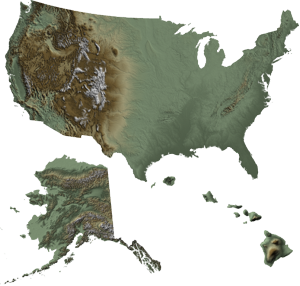
United States Digital Elevation Models
A digital elevation model (DEM) is a 3D digital representation of ground surface topography or terrain. Digital Data Services, Inc. offers United States Digital Elevation Models in 3, 5, 10, 30, 90, and 300 meter resolutions.
With a wide-variety of resolutions and delivered file formats possible, DDS can offer you the right DEM product for your needs. Data can be ordered in a variety of formats and map projections.
3 Meter Resolution Digital Elevation Models- DDS offers 3 meter resolution Digital Elevation Models for the United States, primarily in urban areas.
5 Meter Resolution Digital Elevation Models- Through our partnership with Intermap Technologies, DDS offers 5 meter Digital Surface Models (DSM) and Digital Terrain Models (DTM) for the United States.
10 Meter Resolution Digital Elevation Models- The 10 meter Digital Elevation Model dataset is a compilation of data from a variety of existing high-precision datasets such as LiDAR data, contour maps, and other sources which were reorganized and combined into a seamless dataset. Coverage is for the majority of the lower 48 states.
30 Meter Resolution Digital Elevation Models- The 30 meter Digital Elevation Model dataset was collected and processed using similar processes and source materials as the 10 meter datasets. Coverage is for the entire United States.
90 Meter Resolution Digital Elevation Models- The 90 meter Digital Elevation Model dataset was collected and processed using similar processes and source materials as the 10 meter datasets. Coverage is for the entire United States.
Custom Digital Elevation Models- DDS offers custom DEM creation from topographic maps or from stereo satellite imagery.